Crime & Safety
Twin Cities Residents Survey After-Effects of Winter Storm
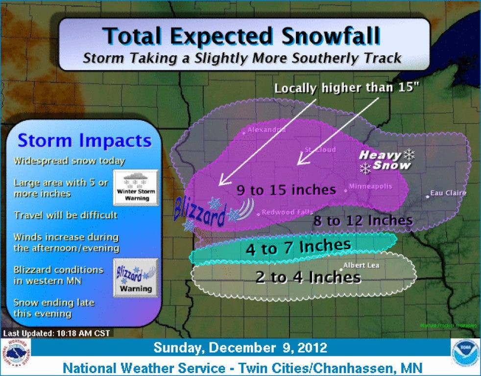
Information on snow accumulations, school closures and traffic and crashes.


UPDATED: 12:10 p.m. Monday.
With the flakes finally coming to a stop, Twin Cities residents are starting to tally the effects of this weekend’s winter storm.
- Accumulations: According to the National Weather Service, nearby St. Louis Park received 10.2 inches of snow as of 9:45 p.m. Sunday.
- Traffic and crashes: At 10:12 a.m. Monday, Lt. Eric Roeske of the Minnesota State Patrol reported that since 9:30 p.m. Saturday, the state had 654 crashes, 67 with injuries and one fatal crash. Police Sgt. Michael Glassberg said Hopkins had two collisions and three vehicles that went into the ditch during the storm. Click here to view the latest traffic conditions.
- School closures: Hopkins Public Schools, like virtually most west metro school districts, did postpone school or close it altogether. The Main Street School of Performing Arts and Ubah Medical Academy have also not announced a closure or postponement.
***
Find out what's happening in Hopkinswith free, real-time updates from Patch.
Original story:
A winter storm warning remains in effect until midnight Monday, Dec. 10, for Hopkins and much of Minnesota, according to an updated alert the National Weather Service issued at 11:24 a.m. Sunday.
Find out what's happening in Hopkinswith free, real-time updates from Patch.
A total of anywhere from 9 to 15 inches is expected to fall on Hopkins by the time all is said and done, with the National Weather Service in Chanhassen forecasting snowfall to wrap up Sunday evening.
Travel is expected to be difficult, with winds increasing in the afternoon and evening.
Worried about traffic conditions? Click here for the latest road updates.
"The heavy snow will taper off this evening with a few snow showers expected thereafter," the National Weather Service said in a winter storm warning. "The wind will then increase from the northwest with drifting snow lingering this evening."
The snow line and city information sources have not yet confirmed that a snow emergency is in effect, although residents are encouraged to remove their vehicles from city streets once snowfall begins. Patch will update this story once further information is available.
Click here for a look at Hopkins’ snow rules in greater detail.
Here is the full text of the warning, issued by the National Weather Service at 11:24 a.m. Sunday:
...FORECAST SNOW AMOUNTS HAVE INCREASED AS MAJOR WINTER STORM CONTINUES...
...BLIZZARD CONDITIONS EXPECTED ACROSS WESTERN MINNESOTA THIS AFTERNOON AND EVENING...
.A BLIZZARD WARNING HAS NOW TAKEN EFFECT FOR MUCH OF WEST CENTRAL MINNESOTA THIS AFTERNOON DUE TO THE COMBINATION OF MODERATE TO HEAVY SNOWFALL AND STRONG NORTHWEST WINDS OF 20 TO 30 MPH...WITH GUSTS NEAR 45 MPH. A WINTER STORM WARNING REMAINS IN EFFECT TODAY FOR EAST CENTRAL MINNESOTA AND WEST CENTRAL WISCONSIN FOR HEAVY SNOWFALL. FAR SOUTHERN MINNESOTA REMAINS UNDER A WINTER WEATHER ADVISORY TODAY FOR LIGHT TO MODERATE SNOWFALL. A POWERFUL WINTER STORM WILL CONTINUE TO AFFECT MINNESOTA AND WEST CENTRAL WISCONSIN FOR THE REMAINDER OF THE DAY. SNOW WILL CONTINUE THIS AFTERNOON AND BECOME HEAVY. BEHIND THE LOW PRESSURE SYSTEM...SUSTAINED NORTHWEST WINDS OF 20 TO 30 MPH ARE EXPECTED OVER WESTERN MINNESOTA THIS AFTERNOON BEFORE GRADUALLY TAPERING OFF THIS EVENING. SOME WIND GUSTS MAY EXCEED 40 TO 45 MPH. CONSIDERABLE BLOWING AND DRIFTING SNOW WILL RESULT IN WHITEOUT CONDITIONS MAKING TRAVEL NEARLY IMPOSSIBLE BY THIS AFTERNOON. AREAS OF BLOWING AND DRIFTING SNOW ARE ALSO EXPECTED FARTHER EAST...BUT LIGHTER WINDS PRECLUDE THE ISSUANCE OF A BLIZZARD WARNING AT THIS TIME. FINALLY...TEMPERATURES WILL PLUMMET BEHIND THE SYSTEM TO WELL BELOW ZERO LATE TONIGHT OVER WESTERN MINNESOTA WITH WIND CHILL READINGS AS LOW AS 20 TO 30 BELOW. TRAVEL IN THE BLIZZARD AND WINTER STORM WARNING AREAS IS NOT ADVISED. TRAVEL WILL BE VERY DIFFICULT AND STRANDED MOTORISTS RISK GETTING FROSTBITE OR HYPOTHERMIA DUE TO THE FRIGID WIND CHILL LATE THIS EVENING AND TONIGHT.
...WINTER STORM WARNING REMAINS IN EFFECT UNTIL MIDNIGHT CST TONIGHT...
* TIMING...SNOW...HEAVY AT TIMES...WILL DEVELOP TODAY. THE HEAVY SNOW WILL TAPER OFF THIS EVENING WITH A FEW SNOW SHOWERS EXPECTED THEREAFTER. THE WIND WILL THEN INCREASE FROM THE NORTHWEST WITH DRIFTING SNOW LINGERING THIS EVENING.
* SNOW ACCUMULATIONS...8 TO 15 INCHES WITH THE HEAVIEST AMOUNTS IN MINNESOTA.
* OTHER IMPACTS...AREAS OF BLOWING SNOW WILL DEVELOP LATE THIS AFTERNOON OVER CENTRAL AND EASTERN MINNESOTA AS NORTHWEST WINDS INCREASE TO 15 TO 20 MPH WITH GUSTS UP TO 30 MPH.
***
Related stories:
- Hopkins' Snow Emergency Continues Through Monday
- PHOTOS: Share Your Snow Photos on Hopkins Patch!
- Latest road conditions
Follow us on Twitter | Like us on Facebook | Sign up for our free daily newsletter | Check out Patch’s Pinterest boards
Get more local news delivered straight to your inbox. Sign up for free Patch newsletters and alerts.


