Community Corner
UPDATE: Warning Issued as Third Winter Storm in Four Weeks Could Mean a Foot of Snow
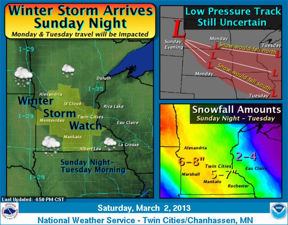
The National Weather Service in Chanhassen has issued a Winter Storm Watch for the Twin Cities and surrounding areas, including Hennepin County. More than 10 inches of new snow could fall on Hopkins.

Yet another winter storm, the third in four weeks, is set to make its arrival in the Hopkins area, dropping heavy snow through Tuesday and bringing some windy conditions to make the morning commute difficult.
The National Weather Service in Chanhassen has issued a winter storm warning for a system now called "Saturn," which should drop its heaviest snow during the Monday evening commute. The warning remains in effect until 6 p.m. Tuesday.
Weather service forecasters say that up to 12 inches of snow may fall in some areas of Minnesota, including Hennepin County. Between six to 10 inches of snow is expected.
Find out what's happening in Hopkinswith free, real-time updates from Patch.
A complete rundown of the system, and the NWS forecast, can be seen in the YouTube video.
Find out what's happening in Hopkinswith free, real-time updates from Patch.
Here's the weather statement issued by the NWS early Sunday morning.
... WINTER STORM WARNING REMAINS IN EFFECT UNTIL 6 PM CST TUESDAY...
A WINTER STORM WARNING REMAINS IN EFFECT UNTIL 6 PM CST TUESDAY.
* TIMING: TWO PERIODS OF SNOW EXPECTED. THE FIRST THIS MORNING THROUGH EARLY THIS AFTERNOON WITH THE SECOND TONIGHT AND TUESDAY. SOME FREEZING DRIZZLE POSSIBLE THIS AFTERNOON. THE SNOW TONIGHT AND TUESDAY WILL BE HEAVY AT TIMES.
* MAIN IMPACTS: SNOW ACCUMULATION OF 6 TO 10 INCHES... WITH ISOLATED AMOUNTS NEAR 12 INCHES POSSIBLE BY TUESDAY EVENING.
* OTHER IMPACTS: EASTERLY WINDS 10 TO 20 MPH TODAY WILL RESULT IN SOME BLOWING AND DRIFTING SNOW IN OPEN AREAS.
PRECAUTIONARY/PREPAREDNESS ACTIONS...
A WINTER STORM WARNING FOR HEAVY SNOW MEANS SEVERE WINTER WEATHER CONDITIONS ARE EXPECTED OR OCCURRING. SIGNIFICANT AMOUNTS OF SNOW ARE FORECAST THAT WILL MAKE TRAVEL DANGEROUS. ONLY TRAVEL IN AN EMERGENCY. IF YOU MUST TRAVEL... KEEP AN EXTRA FLASHLIGHT... FOOD... AND WATER IN YOUR VEHICLE IN CASE OF AN EMERGENCY.
More Information
... SNOW TODAY THROUGH TUESDAY...
.SNOW WAS FALLING EARLY THIS MORNING FROM WEST CENTRAL THROUGH SOUTH CENTRAL MINNESOTA. SNOWFALL AMOUNTS OF 1 TO 3 INCHES HAVE BEEN REPORTED. IN ADDITION... BRISK SOUTHEAST WINDS AT 15 TO 25 MPH WERE CAUSING AREAS OF BLOWING SNOW.
THE SNOW WILL SPREAD ACROSS EASTERN MINNESOTA AND INTO FAR WESTERN WISCONSIN BY DAYBREAK. THE SNOW WILL CONTINUE ACROSS THE REGION THROUGH THE MORNING WITH A DIMINISHING TREND IN THE SNOW FROM WEST TO EAST THIS AFTERNOON. SNOW ACCUMULATIONS TODAY WILL BE IN THE 2 TO 4 INCH RANGE.
THE SNOW WILL INCREASE IN INTENSITY TONIGHT ACROSS EASTERN MINNESOTA AND WEST CENTRAL WISCONSIN... AS AN AREA OF LOW PRESSURE SLIDES SOUTHEAST ACROSS THE REGION. MODERATE TO LOCALLY HEAVY SNOW IS THEN EXPECTED OVERNIGHT AND TUESDAY BEFORE COMING TO AN END TUESDAY NIGHT.
BY LATE IN THE DAY ON TUESDAY... SNOWFALL ACCUMULATIONS OF 6 TO 10 INCHES ARE EXPECTED ACROSS MUCH OF CENTRAL AND SOUTHERN MINNESOTA AND WEST CENTRAL WISCONSIN. THE AXIS OF HIGHEST SNOWFALL ACCUMULATION IS FORECAST NEAR THE MINNESOTA AND WISCONSIN BORDER AREA. SOME STORM TOTALS COULD APPROACH 12 INCHES.
Get more local news delivered straight to your inbox. Sign up for free Patch newsletters and alerts.


